


คำอธิบายของ RTKGPS+
+++++++++++++ DISCLAIMER ++++++++++++++
THIS IS AN ALPHA VERSION
I received some requests to move it to a production
version, for my point of view it works but this version
lacks some extensive tests.
However I changed it to public with this disclaimer.
IT IS PROVIDED AS IS...
WITHOUT ANY WARRANTY.
++++++++++++++++++++++++++++++++++++++
Android RTKLIB frontend.
source code can by downloaded on https://github.com/eltorio/RtkGps
Heavily based on RtkGps from Alexey Illarionov, this is a fork of his work. He allows explicitly to modify and redistribute his work only with the distribution his copyright. You'll find the original license in the "About/Legacy Info" screen. Thanks to all contributors to respect this original license clause.
Since there is no new version I reworked the code for adding some features I need:
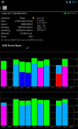
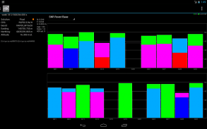
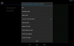
1- show the altitude in the status view.
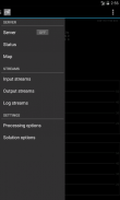
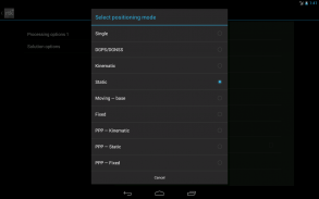
for activating this you need to choose Height:Geodetic in the "Solution Options" view
2- send mock locations to other applications.
for activating this you need to check in the "Solution Options" view Output GPS mock locations, but this is only working if you have allowed "mock locations" in the developer settings (in Android setting).
today (in 1.0alpha13) the mock locations are not usable in the Google map API.
3- automatically upload log file or solution file to your Dropbox account
4- can generate a gpx file of the track
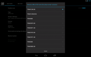
5- can display the result in ECEF, WGS84 Lat/Lon, NAD83, Lambert 93 (RGF93) or UTM (with auto zoning) coordinate system
5b- use any Proj4 projection
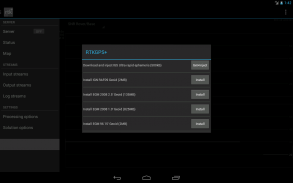
6- can display ellipsoidal height or geodetic altitude (different geoid models can be use see: https://github.com/eltorio/RtkGps for how to install a geoid model)
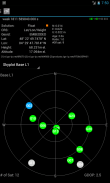
7- use any RTKLIB compliant GNSS with raw output connected via USB (ACM/PL2303/FTDI), Bluetooth, TCPIP or NTRIP
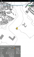
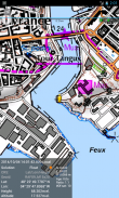
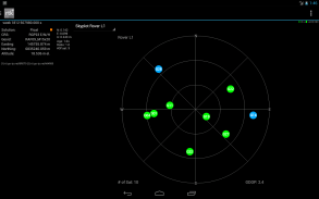
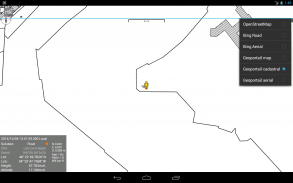
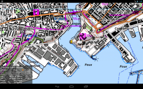
8- can display some maps coming from IGN Geoportail (cadastral parcels, satellite, roads), OpenStreetMap Mapnik, Bing (satellite, roads).
9- can download and use IGS ultra-rapid ephemeris
This software is a port of RTKLIB 2.4.2p9 developed by Tomoki Takasu (http://www.rtklib.com), if you do not know what this application is; this application is probably not what you are looking for!
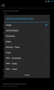
This application can compute precise GPS positions using RTKLIB algorithms (RTK or PPP) but for this you need a supported -external- GPS with raw carrier phase output.
This is not a "standard" GPS like those embedded into your phone or your car, the cheapest one you can find is something like uBlox LEA-6T .
THERE IS NO WAY to use the GPS found in Samsung Galaxy(s) nor any phone I seen.
But there is a special test mode witch use the internal GPS for testing only, obviously none of the precision algorithm found in RTKLIB can be use.
+++++++++++++ ข้อ ++++++++++++++
นี้เป็นรุ่นอัลฟา
ฉันได้รับการร้องขอที่จะย้ายไปยังการผลิต
รุ่นสำหรับมุมมองของการทำงาน แต่รุ่นนี้
ขาดการทดสอบบางอย่างกว้างขวาง
แต่ฉันเปลี่ยนมันให้ประชาชนที่มีข้อนี้
มีให้ตามที่เป็น ...
โดยไม่มีการรับประกันใด ๆ
++++++++++++++++++++++++++++++++++++++
Android RTKLIB ส่วนหน้า
รหัสแหล่งที่มาโดยสามารถดาวน์โหลดได้ https://github.com/eltorio/RtkGps
ขึ้นอยู่อย่างมากใน RtkGps จากอเล็กซ์ Illarionov นี้เป็นทางแยกของการทำงานของเขา ช่วยให้เขาอย่างชัดเจนในการปรับเปลี่ยนและแจกจ่ายงานของเขาเท่านั้นที่มีการจัดจำหน่ายลิขสิทธิ์ของเขา คุณจะพบว่าใบอนุญาตเดิมในหน้าจอ "เกี่ยวกับ / มรดกข้อมูล" ขอบคุณผู้ให้ทุกคนที่จะเคารพข้อใบอนุญาตเดิม
เนื่องจากไม่มีรุ่นใหม่ผมนํารหัสสำหรับการเพิ่มคุณสมบัติบางอย่างที่ฉันต้องการ:
1 แสดงให้เห็นระดับความสูงในมุมมองสถานะ
สำหรับการเปิดใช้งานนี้คุณจะต้องเลือกความสูง: Geodetic ใน "ตัวเลือกโซลูชั่น" มุมมอง
2 ส่งสถานที่จำลองการใช้งานอื่น ๆ
สำหรับการเปิดใช้งานนี้คุณจะต้องตรวจสอบใน "ตัวเลือกโซลูชั่น" มุมมองการส่งออกจีพีเอสสถานที่จำลอง แต่นี้เป็นเพียงการทำงานถ้าคุณได้รับอนุญาตให้ "สถานที่จำลอง" ในการตั้งค่าการพัฒนา (ในการตั้งค่า Android)
วันนี้ (ใน 1.0alpha13) สถานที่จำลองไม่ได้ใช้งานในแผนที่ API ของ Google
3 อัปโหลดไฟล์บันทึกหรือแฟ้มการแก้ปัญหาโดยอัตโนมัติไปยังบัญชีของคุณ Dropbox
4 สามารถสร้างไฟล์ GPX ของแทร็ค
5- สามารถแสดงผลใน ECEF, WGS84 ลาด / โหลน, NAD83 แลมเบิร์ 93 (RGF93) หรือ UTM (มีโซนอัตโนมัติ) ระบบพิกัด
5b- ใช้ใด ๆ ฉาย Proj4
6 สามารถแสดงความสูงของรูปวงรีหรือระดับความสูง (geodetic รุ่นจีออยด์ที่แตกต่างกันสามารถใช้ดู: https://github.com/eltorio/RtkGps สำหรับวิธีการติดตั้งแบบจีออยด์)
7 การใช้งานใด ๆ RTKLIB GNSS สอดคล้องกับการส่งออกดิบเชื่อมต่อผ่าน USB (ACM / PL2303 / FTDI), บลูทู ธ , TCPIP หรือ NTRIP
8 สามารถแสดงแผนที่บางส่วนที่มาจากจีเอ็น Geoportail (ผืนที่ดินดาวเทียมถนน), OpenStreetMap Mapnik, Bing (ดาวเทียมถนน)
9- สามารถดาวน์โหลดและใช้ IGS ไดอารี่พิเศษอย่างรวดเร็ว
ซอฟต์แวร์นี้เป็นพอร์ตของ RTKLIB 2.4.2p9 พัฒนาโดย Tomoki Takasu (http://www.rtklib.com) ถ้าคุณไม่ทราบว่าโปรแกรมนี้เป็น; โปรแกรมนี้น่าจะไม่ใช่สิ่งที่คุณกำลังมองหา!
โปรแกรมนี้สามารถคำนวณตำแหน่งจีพีเอสที่ถูกต้องโดยใช้อัลกอริทึม RTKLIB (RTK หรือ PPP) แต่สำหรับนี้คุณจะต้องได้รับการสนับสนุนจีพีเอส -external- กับผลผลิตขั้นตอนการให้บริการดิบ
นี้ไม่ได้เป็น "มาตรฐาน" จีพีเอสเช่นเดียวกับที่ฝังลงในโทรศัพท์มือถือหรือรถของคุณเป็นหนึ่งที่ถูกที่สุดที่คุณสามารถหาบางสิ่งบางอย่างเช่น Ublox LEA-6T
มีวิธีการใช้จีพีเอสที่พบในซัมซุงกาแล็คซี่ (s) หรือโทรศัพท์มือใด ๆ ที่ฉันเห็นไม่
แต่มีโหมดการทดสอบแม่มดพิเศษใช้จีพีเอสภายในสำหรับการทดสอบเท่านั้นเห็นได้ชัดว่าไม่มีอัลกอริทึมที่มีความแม่นยำที่พบใน RTKLIB สามารถใช้
RTKGPS+--เวอร์ชั่น1.0 Alpha 26
(10-04-2020)RTKGPS+ - ข้อมูล APK
เวอร์ชั่น APK: 1.0 Alpha 26แพ็คเกจ: gpsplus.rtkgpsแอปในประเภทเดียวกัน
คุณอาจจะชอบ...


